


J2 DEFINITIF

CASSISFRAMBOISE
User

Length
18.3 km

Max alt
1674 m

Uphill gradient
932 m
Km-Effort
29 km

Min alt
873 m

Downhill gradient
396 m
Boucle
No
Creation date :
2022-03-08 13:13:17.701
Updated on :
2022-03-08 13:13:38.369
6h34
Difficulty : Medium

FREE GPS app for hiking
 SityTrail
IGN / Geographical institutes
SityTrail Plus
The world is yours!
About
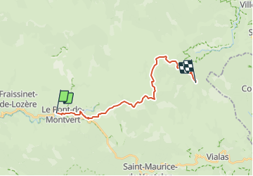
Trail On foot of 18.3 km to be discovered at Occitania, Lozère, Pont de Montvert - Sud Mont Lozère. This trail is proposed by CASSISFRAMBOISE.
Positioning
Country:
France
Region :
Occitania
Department/Province :
Lozère
Municipality :
Pont de Montvert - Sud Mont Lozère
Location:
Le Pont-de-Montvert
Start:(Dec)
Start:(UTM)
558844 ; 4912567 (31T) N.
Comments